Setting and Boundaries
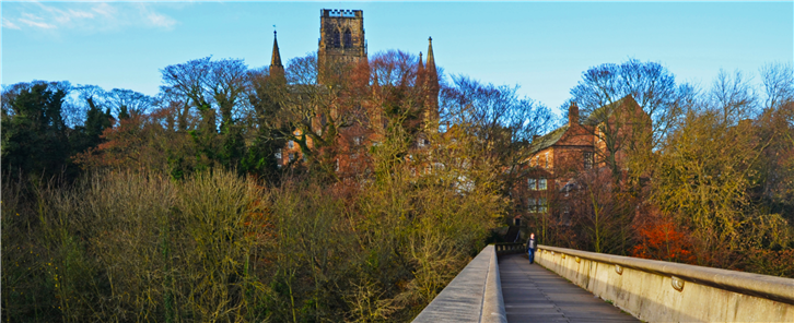
Figure 4.1: View of WHS from Kingsgate Bridge
4.1 Introduction
This chapter identifies what is needed to protect, sustain and conserve the site’s OUV through its setting, key views and the definition of the WHS boundary. This is set in the context of changes in policy and guidance, and an assessment of current management issues. Three topics are identified: 1) expanding the WHS boundary, 2) clarifying the inner setting of the WHS and, 3) dealing with longer distance views and key historic or popular views. Supporting detailed consideration is provided in Appendix 1.
4.2. Outstanding Universal Value
Identification of the significance of the WHS and its expression in the OUV is the starting point for considering how the site may be supported and protected from harm. Meeting the UNESCO World Heritage Committee’s criteria for defining significance relies on key attributes that are further explored in Chapter 2, Section 3. There has been substantial work since the 2006 management plan on conservation management plans for key parts of the WHS and the Peninsula. These have substantially clarified the extent and significance of the defences to the peninsula and the Riverbanks which, in turn, has led to greater understanding of where there is need for boundary review in order to ensure the protection of the OUV.
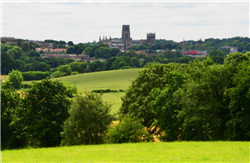
Figure 4.2:View from the North East, Frankland Lane
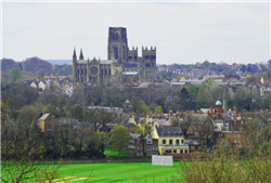
Figure 4.3: View from the North East overlooking the racecourse

Figure 4.4: View from the North, Akeley Heads
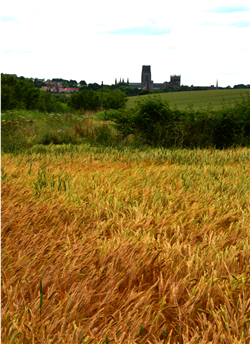
Figure 4.5: View from the North East, Frankland Lane
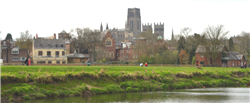
Figure 4.6: View from the North East from Frankland Lane

Figure 4.7: View from the East
4.2.1 Criteria
All three applicable UNESCO criteria support the understanding of site extent and setting but the most relevant is Criterion (iv) that requires an ‘….architectural ….ensemble…or landscape which illustrates significant stages in human history’
4.2.2 SOUV Site Significance
Key references from the SOUV for identifying the extent, extents, setting and views of the WHS are:
‘The visual drama of the Cathedral and Castle on the peninsula and the associations with notions of romantic beauty;
The physical expression of the spiritual and secular powers of the medieval Bishops Palatine that the defended complex provides;’
4.2.3 Attributes
The attributes defined within Chapter 2, Section 3 identify the contribution of the site’s significance, its skyline, the relationship to the river, the scale and monumentality of the key buildings to the OUV. This contribution derives from the relationship of the core buildings to their immediate surrounds, the surrounding townscape and the more distant landscape from which the WHS and its context are viewed. From this it follows that significance lies in not just the site as defined but also in its relationship to the river, townscape and the enclosing landscape. These are physical attributes but their importance is enhanced by the site’s cultural significance which, while less tangible, is also central to its designation as a WHS.
4.2.4 Appreciation of the Site and Its Attributes
The appreciation of Durham WHS, its buildings and setting is immediate and easily shared by visitors to the site. The full extent of the site and its setting is less understood by visitors and does not normally form part of their exploration of Durham and surrounds. Much of the immediate landscape has been enveloped by trees during the 20th century that obscure the earlier landscape of the WHS but, more positively, create a green and rich setting for the river and main buildings.
In addition to understanding the overall integrity of the site and its landscape, the Management Plan needs to identify these increasingly hidden attributes of the site and its setting, extend understanding and appreciation of them and thus enable assessment of the impact of change resulting from development. Analysis of such impact relies on a full appreciation of the way the site interacts with its setting, townscape and landscape.
4.3 Threats and Risks
The Management Plan is intended to promote the well-being of the WHS and to ensure that threats and risks to the site, from whatever cause, are avoided. The Planning system is the principal way to protect the WHS from adverse development, but not all potential threats and risks to the WHS require planning permission so this objective of protecting the WHS is aided by increasing understanding among all interested parties of the character of the WHS and of ways to avoid damaging it. While Historic England advises the avoidance of overly-close definition of setting, because of what can be missed in the definition process, Durham’s WHS setting is open to physical description. Therefore, the Management Plan identifies and describes the inner setting sufficiently to aid assessment of proposals that would affect the WHS, thereby assisting landowners and potential investors.
4.4 Buffer Zone
A buffer zone is an area of extended protection surrounding a WHS site and is generally considered necessary to protect the site’s OUV. The creation of such a zone needs to be considered as part of assessing the setting of the WHS or of proposing any amendments to the WHS boundary.
It is not considered that the protection offered by a buffer zone is necessary in Durham providing there is sufficient understanding of the site’s significance and the contribution made by the setting to that significance. This should also be reinforced by an appropriate boundary for the WHS area that ensures protection of the OUV. This approach to protection would be subject to appropriate approval of any WHS expansion proposals and will need reassessment if expansion does not prove possible.
4.5 The Inner Setting for the World Heritage Site
The ridges and hill tops surrounding the historic core of the city provide a clear physical framework enclosing the inner setting in which the WHS sits. There is scope to use topographical analysis and WHS building heights to describe the inner setting which, in turn, will assist with assessment of development proposals that might be affected by the site’s significance and OUV.
The suggested area for inner setting description is shown on Plan 1.
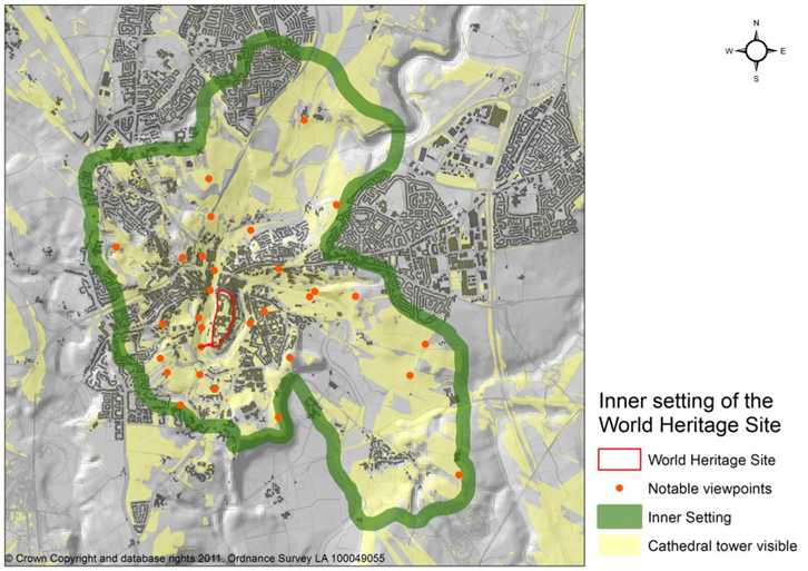
Plan 1
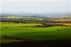
Figure 4.8: Distant View from the South East
4.6 The Outer Setting for the World Heritage Site
It is less easy to fully describe the outer setting but useful guidance in relation to views can be given. There are views of and from the Cathedral from many directions that are of significance both in visual and historical terms and these must be protected. Therefore, greater emphasis will be placed on the possible negative impact on the setting of the WHS arising from development within the outer setting area. The extents of views to the Cathedral are demonstrated by Plan 2A and key areas are shown on Plan 2B.
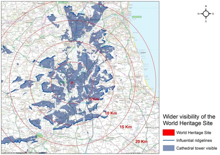
Plan 2A
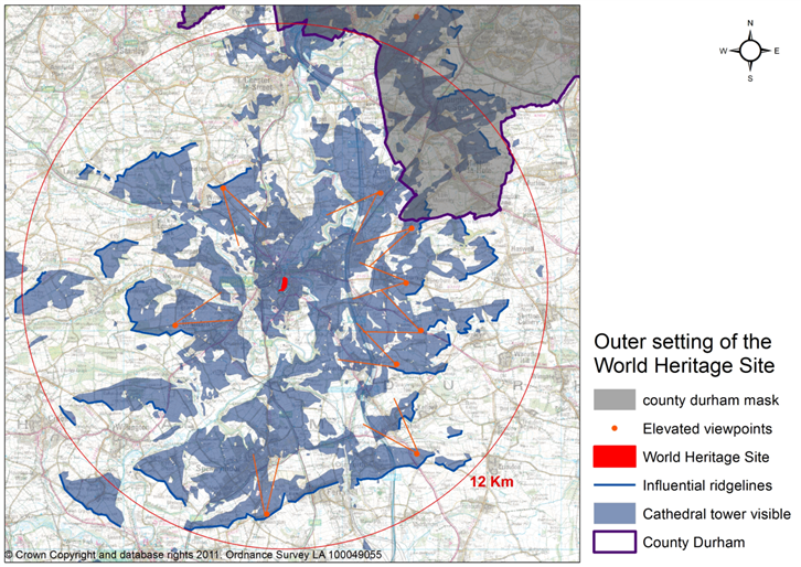
Plan 2B
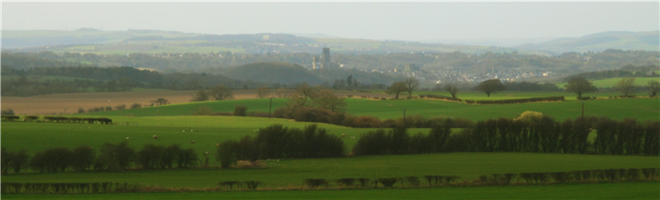
Figure 4.9: Mid Distance View from the East

Figure 4.10: View from the East
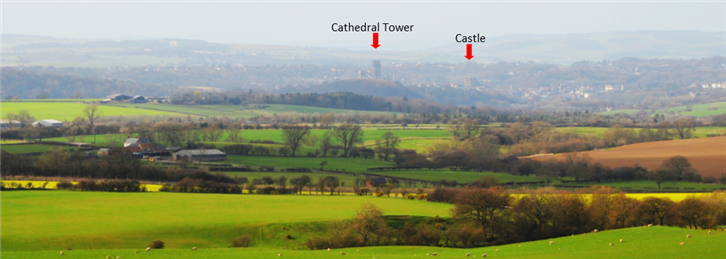
Figure 4.11: Outer Setting—View from the South East
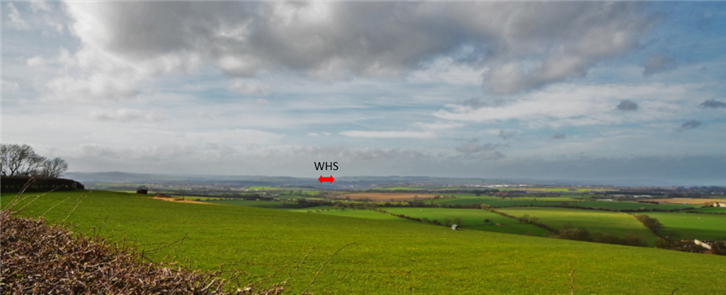
Figure 4.12: Outer Setting—View from the South East
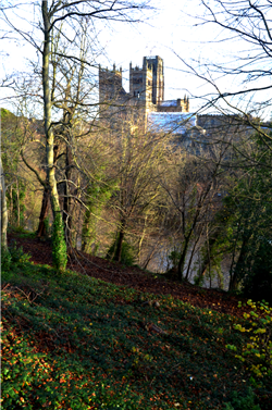
Figure 4.13: View from the West, South Street
4.7 Understanding Durham’s Unique Townscape and Landscape
There are a number of particular traits that contribute to the character of the WHS, the inner setting and surrounding landscape and thus relate to the Site’s Outstanding Universal Value. In order to assist with analysis of the potential for proposed development to make a positive contribution to the WHS, the range of these attributes is described in Appendix 1
4.8 Potential Expansion of the World Heritage Site
The driving principle behind the suggestion to expand the WHS is the desirability of including all of the Peninsula and its defensive structures and functions within the WHS. This would more closely relate the WHS to its immediate landscape which contains areas that have evolved with the WHS. A more detailed investigation into the potential for expansion of the WHS can be found in Appendix 1, and suggestions for the expansion are shown on Plan 3.
Site expansion will not be pursued if it necessitates a complete reapplication for WHS status. Should that prove necessary, the alternative course of action will be to reassess the description of the setting and the level of protection it affords.
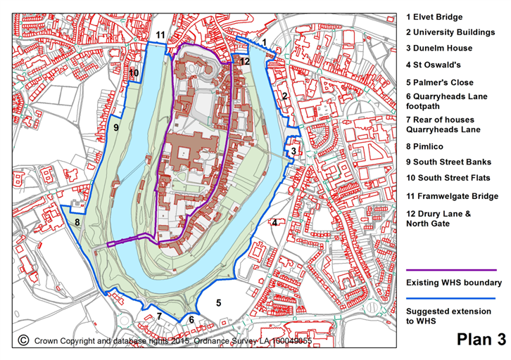
Plan 3
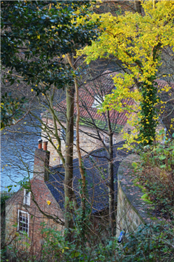
Figure 4.14: The Fulling Mill
4 .9 Conservation and Management
Conservation and management of the site and its assets will be aided by rationalising the WHS boundary to include all the peninsula and by increasing understanding of the justification for the inner and outer settings of the WHS. This will also assist everyone involved in the development and management of the site, and in the exercise of powers under the statutory planning system.
4.10 Actions
- To review the inner and outer riverbanks for an expanded WHS area;
- To advance the detailed justification for inclusion of additional land in an expanded WHS and to secure the necessary ICOMOS and UNESCO ratification, providing that this does not trigger reapplication for WHS status;
- To cooperate with partners to pursue adequate support for an inner setting area around a potentially expanded WHS core area, in lieu of a buffer zone;
- To provide detailed assessment and justification that will increase understanding of the inner setting, particularly through the analysis of views and more general analysis of the setting.
- To assess view corridors to the WHS, skylines and backdrops to views, identifying their character and significance to the WHS;
- To promote adequate assessment of harm by development proposals on the OUV of the site including views and the inner and outer setting and in particular to promote the use of the International Council on Monuments and Site’s (ICOMOS) Heritage Impact Assessment;
- To assist constructive conservation by making descriptions of significance and key factors forming the character of the townscape that supports the site’s OUV available to prospective developers,.
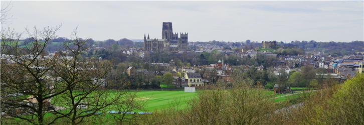
Figure 4.15: View from the East